GIS for Climate Stewardship and Meaningful Community Engagement
Communities around the world are seeking innovative solutions to mitigate climate change effects and advance resilience to adapt to the changing environment. Geographic Information Systems (GIS) technology provides easy to use and yet powerful tools for climate stewardship and meaningful community engagement. By visualizing and analyzing geospatial data, communities can better understand climate-related challenges, develop effective strategies, and involve all stakeholders early in the decision-making process.
But how?
Visualizing Climate Impacts & Analyzing Vulnerability and Risk
Imagine if you could see the future of your community!
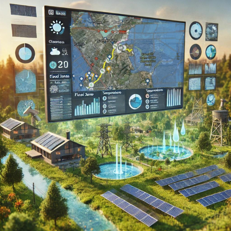
That’s the power of Geographic Information Systems (GIS). By visualizing and overlaying data tied to any location, we can unveil hidden patterns, spot vulnerabilities, and make informed decisions to build a more resilient tomorrow. The possibilities are endless and so is our ability to come up with sustainable solutions.
GIS takes the vast amounts of data we have about our planet and transforms it into stunning visualizations that reveal hidden patterns and trends. By layering climate data over detailed maps of communities, planners and analysts can identify the exact neighborhoods threatened by rising temperatures, sea water, devastating floods, and raging wildfires. They can assign risk scores to different areas, highlighting the most vulnerable populations and infrastructures.
GIS analyses can reveal the deep inequities that exist in our society and how climate change will exacerbate them by integrating demographic and socioeconomic data. They can show how floodwaters will disproportionately engulf affordable housing, how heatwaves will sicken the elderly and the poor, and how the destruction of natural habitats will threaten the livelihoods of indigenous communities. It can also show which neighborhood was involved in the decision making process and which was overlooked!
Case Studies
Several communities are already leveraging GIS for climate stewardship and engagement. The City of Boston, for instance, used GIS to develop a comprehensive climate resilience plan that involves flood protection measures, green infrastructure, and equity-focused initiatives. In Miami, GIS mapping revealed how gentrification is exacerbating climate vulnerability in low-income neighborhoods, informing policies to protect affordable housing and invest in climate resilience. In Minnesota, GIS was used to address childhood poverty. In Montana, GIS was used to ensure equitable distribution of infrastructure funds. It can be used at all levels and project sizes to ensure meaningful community engagement and sustainable impact.
Conclusion
The power of GIS lies in its ability to deal with complex systems and transform complexity into clarity. It’s a tool to engage communities often overlooked, ensuring they’re part of the solution they so desperately need. It’s a platform to visualize not just the threats, but the ways we can alleviate disaster and migration pressures. By leveraging GIS, communities can create a more climate-resilient and equitable future for all residents. Contact us for more information and to find out more how A&D Solutions use GIS tools for climate stewardship, environmental justice, community benefits, climate resilience and resilience plans.
Resources
- Esri’s Climate Resilience Resources: https://www.esri.com/en-us/about/climate-action/overview
- Maps Help Ensure Equitable Distribution of Infrastructure Funds in Montana: Maps Help Ensure Equity in Montana Infrastructure Upgrades (esri.com)
- The Trust for Public Land’s Climate Mapping Tool: https://web.tplgis.org
- NOAA’s Digital Coast Platform: https://coast.noaa.gov/digitalcoast/
- The City of Boston’s Climate Resilience Plan: https://www.boston.gov/departments/environment/climate-resilience-boston
- ESRI USER Conference 2024Conta